-40%
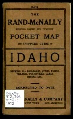
RAND MCNALLY IDAHO 1912 POCKET MAP RR SHIPPERS GUIDE ID RAILROADS CITIES RIVERS
$ 51.73
- Description
- Size Guide
Description
RAND MCNALLY IDAHO 1912 POCKET MAP RR SHIPPERS GUIDE ID RAILROADS CITIES RIVERSItem:
Pocket Map and Shippers' Guide of Idaho
Subtitle:
Accompanied by a compilation and ready reference index, showing in detail the entire Railroad system
Date:
1912
Color/B&W:
Fold-out color map of Idaho
Content:
The Express Company doing business over each road, and accurately locating all:
Cities
Towns
Post Offices
Railroad Stations
Villages
Counties
Islands
Lakes
Rivers
Etc.
Special Features:
Railroad Station Locations
Nearest Mailing Point
MO Post Offices
Telegraph Stations
Naming the Express Company doing business at the points where the several companies have offices
Latest population census
Indexed:
County and township
Publisher:
Rand-McNally & Co.
Pages:
38 pages of text and ads
Size:
Booklet: 4½ x 6¾"
Map: 21 x 28"
Color/Stock:
Softbound - Brown light card stock cover
CC ID #:
MID 9017
Please see our other Maps and many collectibles!
Click here for our Pikes Peak Shadow listings
Powered by SixBit's eCommerce Solution
